 Filter: Categories of Wisconsin Historical Images
Filter: FORMAT_DIMENSIONS of 55 x 42 cm.
Filter: Categories of Wisconsin Historical Images
Filter: FORMAT_DIMENSIONS of 55 x 42 cm.

| Date: | 1941 |
|---|---|
| Description: | This pictorial map of Wisconsin with historical text highlights the history of the state and identifies places of interest, Indian villages, missions, trad... |
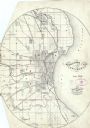
| Date: | 06 1858 |
|---|---|
| Description: | This map shows additions and subdivisions to Milwaukee, city wards, roads, railroads, and selected buildings. This map was engraved to accompany the city d... |

| Date: | 1990 |
|---|---|
| Description: | This map shows various types of trails, boat landings, canoe areas, public beaches, picnic areas, campgrounds, golf courses, public tennis courts, and othe... |
If you didn't find the material you searched for, our Library Reference Staff can help.
Call our reference desk at 608-264-6535 or email us at: